Kievtown.net
Kiev travel guide
Kievtown.net Kiev travel guide |
|
|||
|
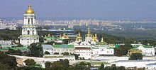
Kiev map underwent changes for centuries. It hardly possible to ascertain topography of old Kiev exactly. Most of conjectures are made on the ground of disembodied and contradicting facts. According to some information, in 11 century Kiev borders were outlined by high earth mounds, which stretched from Lvov square along Jaroslavov Val Street. Having reached Golden gate – main Kiev, mounds went down to Independence Square, and then run upwards to Mihaylovsky square. Probably, it was not absolutely so, as according to this variant, Podol was not included in city borders, but we know that it was actively occupied as Kiev district already in 10 century.
Today Kiev borders are moved apart by lips and bounds. Kiev map can be useful not only for those, who arrived to Ukraine capital for the first time. Sometimes, even those, who know city well, should use Kiev map to estimate optimum route or locate exact position of object. Modern Kiev electronic map enable to see streets’ location and houses’ numbering, it is possible to find almost any object at the map: monument, business or entertainment centre, bank or administrative institution.
|
Авиабилеты дешево
buruki.ru - дешевые авиабилеты |
|